Nkpoku-Bomu Trunk Line
Nkpoku-Bomu Trunkline at Kporghor/Gbam in Tai Local Government Areas (LGAs) of Rivers State The site lies between geographic coordinates N04° 42’ 56.22” and E E07° 13’ 24.74” (WGS 84) .
Joint Investigation Visit was conducted on 11th February 2015 for the 2015_1335376 incident, 18th February 2016 for the 2016_1572504 incident and 7th-9th October 2016 for the 2016_1726801 incident.
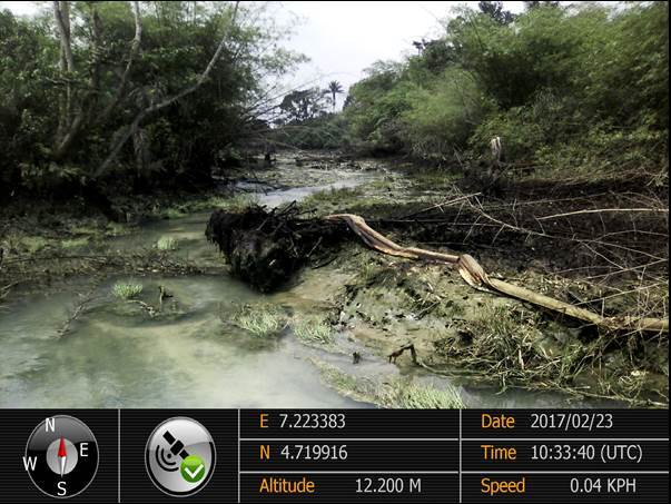
Section 1 before Remediation work
Section 2 before Remediation work
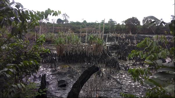
Section 3 before Remediation work
Underground oil seepage from adjoining crude oil theft site- Source of continuous re-pollution at Zone 3 (3m depth).
The project covered an area remediated of 5,000m² with a 6m excavation depth and 30,000m³ of soil treated, addressing a total crude oil spill volume of approximately 74.9 barrels across about 5.274 hectares within and outside the SPDC Right of Way as documented in the JIV report, located at coordinates N04° 42’ 56.22” – N04° 43’ 15.54” and E07° 13’ 17.84” – E07° 13’ 24.74” (WGS 84), where a Tier 1 assessment by International Energy Services Limited (6–21 September 2016) indicated a 5.5255-hectare (55,255m²) impacted area with TPH exceedances necessitating remediation, all situated in the agrarian Kporghor-Gbam community whose subsistence farming economy relies on cassava, palm trees, and bamboo trees, with land use primarily as pipeline Right of Way but functioning additionally as pedestrian routes to farms, creeks, and villages, featuring vegetation such as palm trees, bamboo, shrubs, and mangroves, divided by a river network connected to creeks reaching Wakama, Gio, and Ogu communities, with a cassava farm observed 40m east of the project area and no residential structures present.
The scope of work involved remediation of 11,400m3 of impacted soil to depths range between 0.2m in the creek and 1m-2.5m on the shorelines over and area of 18,400m2
- Raking, flushing, burning oily debris and land farming of the burnt residue
- Recovery & evacuation of residual crude oil (12,000 liters)
- Mechanical excavation and backfilling of contamination hotspots along the SPDC RoW and shoreline areas covering an area of 5,900m2 and 8,900m3 volume of soil)
- Manual agitation of 2,500m3 volume of soil to a depth of 0.2m & flushing in the creeks over an area of 12,500m2
- Final mechanical/manual tilling and homogenization of the areas using an excavator, shovel, rakes and wheelbarrows.
- Preparation and submission of a project report.
The remediation activities at this site suffered several setbacks as there were repeated cycles of re-pollution arising from illegal activities of oil bunkers.
The river that runs through the middle of the site is connected to several creeks linking neighbouring communities of Ogu, Bolo, Wakama, Gio etc. As a result, oil bunkerings activities and destruction of bunkering barges by government security forces (Joint Task Force- JTF) in the creeks of these communities bring in spilled product and re-contaminate already remediated sections of the site.
Another re-pollution source at this site is the illegal bunkering sites bordering section B at the zone 2 & 3 area where there was continuous seepage of free phase oil into remediated area which led to the recovery of over 10,000 litres of crude oil from pits dug at that section to contain the re-pollution.
Joint inspection visits with NOSDRA, RSMEnv , HYPREP, Community Reps and SPDC acknowledged the remediation effort by SPDC, however, it was agreed by parties that progressive sampling of remediated areas be carried out for regulatory closeout, noting that a more holistic approach to capture the adjoining bunkering sites will necessary to stem re-pollution coming from those areas and stoppage of oil theft and bunkering will bring a lasting solution to the problem.
The communities were charged to report illegal activities in their areas to the government in order to achieve a cleaner environment, and although the sampling exercise directed and supervised by NOSDRA & RSMEnv took place between 4th–12th May 2017 and the results are still being awaited, the use of enhanced bioremediation/landfarming successfully remediated 55,679m³ of contaminated soils, but with sources of re-pollution still active and posing a risk of re-impact, the site has nonetheless been remediated with regulatory certification sampling completed and pending results, and it remains essential for government and community stakeholders to discourage crude oil theft by youths to completely free the environment from hydrocarbon contamination and sustainably achieve the overall goal of the remediation exercise in promoting a healthy environment.